
정보
-
업무명 : 대기 환경 자료 처리 및 가시화 : 태양 위치 정보를 이용하여 태양 천정각 (Solar Zenith Angle) 및 태양 방위각 (Solar Azimuth Angle) 가시화
-
작성자 : 이상호
-
작성일 : 2020-03-31
-
설 명 :
-
수정이력 :
내용
[개요]
-
안녕하세요? 기상 연구 및 웹 개발을 담당하고 있는 해솔입니다.
-
대기 환경 정보는 다양한 차원의 관측 자료 및 분석 자료로 구성되어 있기 때문에 이용자가 적절한 분석 및 가시화 기술이 요구됩니다.
-
따라서 오늘 포스팅에서는 태양 위치 정보를 이용하여 태양 천정각 (Solar Zenith Angle) 및 태양 방위각 (Solar Azimuth Angle) 가시화를 소개해 드리고자 합니다.
-
추가로 대기과학 전공자를 위한 IDL를 소개한 링크를 보내드립니다.
[IDL] 아이디엘 대기과학 전공자를 위한 IDL (Interactive Data Language) 소개
정보 업무명 : 대기과학 전공자를 위한 IDL (Interactive Data Language) 소개 작성자 : 이상호 작성일 : 2020-03-23 설 명 : 수정이력 : 내용 [개요] 안녕하세요? 웹 개발 및 연구 개발을 담당하고 있는 해솔입니..
shlee1990.tistory.com
[특징]
-
대기 환경 자료를 이해하기 위해서 자료 처리 및 가시화 기술이 요구되며 이 프로그램은 이러한 목적을 달성하기 위해 고안된 소프트웨어
[기능]
-
시간 및 위/경도에 따른 태양 위치 정보 계산
-
태양 천정각 및 태양 방위각 가시화
[활용 자료]
-
없음
[사용법]
-
입력 자료를 동일 디렉터리에 위치
-
소스 코드를 실행 (idl -e Visualization_Using_Sun_Position)
-
가시화 결과를 확인
[사용 OS]
-
Windows 10
[사용 언어]
-
IDL v8.5
소스 코드
-
해당 작업을 하기 위한 컴파일 및 실행 코드는 IDL로 작성되었으며 가시화를 위한 라이브러리는 Coyote's Guide to IDL Programming를 이용하였습니다.
-
소스 코드는 단계별로 수행하며 상세 설명은 다음과 같습니다.
-
1 단계는 주 프로그램은 작업 경로 설정, 태양 위치 정보를 메모리상에 저장하고 가시화를 위한 초기 설정합니다.
-
2 단계는 plot 매핑에 따라 영상 장면 표출하여 이미지 형식으로 저장합니다. 이 과정에서 포스트 스크립트 (PS) 형식에서 PNG로 변환합니다.
-
[명세]
-
전역 변수 설정
-
cd를 통해 작업 디렉터리 설정
-
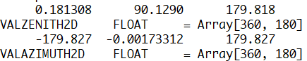
배열 정보 확인 (dim)
-
위도 (lon1D), 경도 (lat1D), 태양 천정각 (valZenith2D), 태양 방위각 (valAzimuth2D)에 대한 배열 설정
-
위도 및 경도는 각각 100 km 간격으로 180 및 360개 격자 구성
-
cd, 'C:\SYSTEM\PROG\IDL\Satellite_Angle'

dim = [360, 180]

lon1D = fltarr(dim[0])
lat1D = fltarr(dim[1])
valZenith2D = fltarr(dim[0], dim[1])
valAzimuth2D = fltarr(dim[0], dim[1])

lon1D = -180.0 + findgen(dim[0])
lat1D = 90.0 - findgen(dim[1])
-
태양 위치 정보 읽기
-
SunPosition 및 시간 (day, hour)과 위/경도 (lat1D, lon1D)를 통해 1차원 태양 천정각 (zenith), 태양 방위각 (azimuth) 계산
-
해당 1차원 결과를 2차원으로 변환
-
for day = 1L, 1 do begin

    for hour = 0L, 24 do begin

        for iCount = 0L, dim[0] - 1 do begin
            SunPosition, day, hour, lat1D, lon1D[iCount], zenith, azimuth

            valZenith2D[iCount, *] = zenith[*]
            valAzimuth2D[iCount, *] = azimuth[*]
        endfor

        # 중략

    endfor
endfor
-
요약 통계량 확인
-
최소값 (min), 평균값 (mean), 최대값 (max) 계산
-
help를 통해 자료형 및 배열 정보 확인
-
print, min(valZenith2D, /nan), mean(valZenith2D, /nan), max(valZenith2D, /nan)
help, valZenith2D

print, min(valAzimuth2D, /nan), mean(valAzimuth2D, /nan), max(valAzimuth2D, /nan)
help, valAzimuth2D
-
가시화
-
데이터 세트에서 정보는 여전히 숨겨져 있기 때문에 가시화 필요
-
가시화는 일반적인 정적 탐색 데이터 분석에서 웹 브라우저의 동적 대화식 데이터 시각화에 이르기까지 다양함
-
-
태양 천정각 및 태양 방위각을 위한 설정 및 가시화
-
관심 영역 (ROI)와 중심 위/경도 (cnLon, cnLat) 설정
-
이미지 저장 파일명 (psName) 및 제목명 (mainName)
-
fnMakePsPlot를 통해 이미지 저장
-
cnLat = 0
cnLon = 0
ROI = [-90, 90, -180, 180]
dtDateYmdH = string(day, "_", hour, format='(i3.3, a1, i2.2)')
print, dtDateYmdH
psName = "Img01_" + dtDateYmdH
mainName = "Solar Zenith Angle : " + dtDateYmdH
fnMakePsPlot, lon1D, lat1D, valZenith2D, dim, cnLat, cnLon, ROI, psName, mainName, 0, 180, 30, 33
psName = "Img02_" + dtDateYmdH
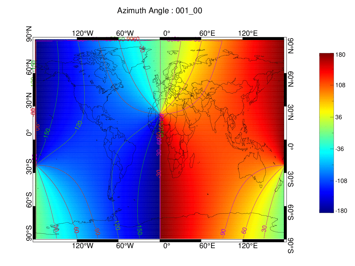
mainName = "Azimuth Angle : " + dtDateYmdH
fnMakePsPlot, lon1D, lat1D, valAzimuth2D, dim, cnLat, cnLon, ROI, psName, mainName, -180, 180, 30, 33
-
태양 천정각 (001일 00시)

-
태양 방위각 (001일 00시)

-
동영상 애니메이션 설정
-
반복문 수행한 이후 spawn를 통해 1초마다 동영상 애니메이션 생성
-
com = "convert -loop 0 -delay 100 "+ "./FIG/Img01_*.png" + " " + "./GIF/Img01.gif"
spawn, /hide,  com

com = "convert -loop 0 -delay 100 "+ "./FIG/Img02_*.png" + " " + "./GIF/Img02.gif"
spawn, /hide,  com
-
태양 천정각 (001일 00-24시)

-
태양 방위각 (001일 00-24시)
-
비디오 동영상
-
태양 천정각 (000-365일 00-24시)
-
태양 방위각 (000-365일 00-24시)
-
사용자 편의성 함수 정의
-
전달 인자
-
1차원 위도 (lon1D), 1차원 경도 (lat1D), 2차원 값 (val2D), 배열 정보 (dim), 중심 위도 (cnLat), 중심 경도 (cnLon), 관심 영역 (ROI), 이미지 저장 파일명 (psName), 제목명 (mainName), 최소값 (zmin), 최대값 (zmax), 등고선 간격 (interval), 컬러 테이블 (color_table)
-
-
기능
-
plot를 통해 위/경도에 따른 값 매핑
-
포스트 스크립트 (PS)를 PNG로 변환
-
-
;====================================================================
; Subroutine : Function Make Postscript to Png Graph
;====================================================================
pro fnMakePsPlot, lon1D, lat1D, val2D, dim, cnLat, cnLon, ROI, psName, mainName, zmin, zmax, interval, color_table

    set_plot, "ps"

    device, filename = psName + ".ps", decomposed=0, bits=8, /color, xsize=16, ysize = 12, /inches, font_size = 13, /Helvetica

    !p.font = 0 & !p.charsize = 2.0 & !p.charthick = 1.6  & !p.multi = [0,1,1] & !p.background = 255

    xvert = [0.1, 0.1, -0.1, -0.1 ,0.1]
    yvert = [-0.1, 0.1, 0.1, -0.1, -0.1]

    usersym, xvert, yvert, /fill

    start_color = 0 & end_color = 255 & colorn = end_color - start_color + 1

    cgloadct, color_table

    latmin = ROI(0) & latmax= ROI(1) & lonmin = ROI(2) & lonmax= ROI(3)

    cgMAP_SET, cnLat, cnLon, /CYLINDRICAL $
      , limit = [latmin, lonmin, latmax, lonmax] $
      , position = [0.1, 0.1, 0.8, 0.85], /noborder

    for i = 0L, dim[0] - 1 do begin
      for j = 0L, dim[1] - 1 do begin

        nLon = lon1D[i]
        nLat = lat1D[j]
        nVal = val2D[i, j]

        if (lonmin gt nLon or nLon gt lonmax or finite(nLon, /nan) eq 1) then continue
        if (latmin gt nLat or nLat gt latmax or finite(nLat, /nan) eq 1) then continue
        if (finite(nVal, /nan) eq 1) then continue

        plots, nLon, nLat, psym = 8, symsize = 5, color = BYTSCL(nVal, zmin, zmax)

      endfor
    endfor

    cgColorbar, NColors = 255, BOTTOM = 1 $
      , Divisions = 5, COLOR = "black" $
      , Position = [0.2, 0.90, 0.8, 0.94] $
      , Range = [zmin, zmax] $
      , CHARSIZE = 1.5,CHARthick = 2 $
      , VERTICAL = 1, RIGHT = 1

    cgLoadct, 2

    contour, val2D, lon1D, lat1D, /overplot, C_THICK = 2 $
      , LEVELS = zmin + findgen(10) * interval $
      , C_LABELS = zmin + findgen(10) * interval $
      , C_CHARSIZE = 1.5, C_CHARTHICK = 2 $
      , C_COLORS = BYTSCL(zmin + findgen(10) * interval, zmin, zmax)

    cgMAP_CONTINENTS, /coast, /countries, COLOR = "black"

    lats = [-90:90:30]
    lons = [-180:360:60]

    lats_names = strarr(n_elements(lats))
    lons_names = strarr(n_elements(lons))

    for i = 0L, n_elements(lats) - 1 do begin
      if (lats[i] gt 0) then begin
        lats_names[i] = textoidl(string(lats[i]) + "\circN")
      endif else if (lats[i] eq 0) then begin
        lats_names[i] = textoidl(string(lats[i]) + "\circ")
      endif else begin
        lats_names[i] = textoidl(string(-lats[i]) + "\circS")
      endelse
    endfor

    for i = 0L,n_elements(lons) - 1  do begin
      if (lons[i] gt 0) then begin
        lons_names[i] = textoidl(string(lons[i]) + "\circE")
      endif else if (lons[i] eq 0) then begin
        lons_names[i] = textoidl(string(lons[i]) + "\circ")
      endif else begin
        lons_names[i] = textoidl(string(-lons[i]) + "\circW")
      endelse
    endfor

    cgMap_grid, color = "black", charsize = 1.8, thick = 2.5, lats = lats,  latnames = lats_names, lons = lons, lonnames = lons_names $
      , linestyle = 1, bthick = 300, /box_axes, /no_grid

    cgText, 0.45, 0.95, mainName, /normal, charsize = 2, CHARTHICK = 2, color = "black", alignment = 0.5

    device, /close_file

    com = "convert -flatten -background white " + psName + ".ps" + " " + "./FIG/" + file_basename(psName, ".ps") + ".png"
    spawn, /hide, com

  ;  file_delete, ps_name + ".ps"

    return

end
-
태양 위치 정보에 필요한 라이브러리
pro SunPosition,day,time,lat,lon,zenith,azimuth,solfac,sunrise=sunrise, $
  sunset=sunset,local=local,latsun=latsun,lonsun=lonsun
  ;+
  ; ROUTINE:      SunPosition
  ;
  ; PURPOSE:      Compute solar position information as a function of
  ;               geographic coordinates, date and time.
  ;
  ; USEAGE:       zensun,day,time,lat,lon,zenith,azimuth,solfac,sunrise,sunset,
  ;                  local=local
  ;
  ; INPUT:
  ;   day         Julian day (positive scalar or vector)
  ;               (spring equinox =  80)
  ;               (summer solstice= 171)
  ;               (fall equinox   = 266)
  ;               (winter solstice= 356)
  ;
  ;   time        Universal Time in hours (scalar or vector)
  ;
  ;   lat         geographic latitude of point on earth's surface (degrees)
  ;
  ;   lon         geographic longitude of point on earth's surface (degrees)
  ;
  ; OUTPUT:
  ;
  ;   zenith      solar zenith angle (degrees)
  ;
  ;   azimuth     solar azimuth  (degrees)
  ;               Azimuth is measured clockwise from due north
  ;
  ;   solfac      Solar flux multiplier.  SOLFAC=cosine(ZENITH)/RSUN^2
  ;               where rsun is the current earth-sun distance in
  ;               astronomical units.
  ;
  ;               NOTE: SOLFAC is negative when the sun is below the horizon
  ;
  ;
  ; KEYWORD INPUT:
  ;
  ;   local       if set, TIME is specified as a local time and SUNRISE
  ;               and SUNSET are output in terms of local time
  ;
  ;               NOTE: "local time" is defined as UT + local_offset
  ;                     where local_offset is fix((lon+sign(lon)*7.5)/15)
  ;                     with -180 < lon < 180
  ;
  ;                     Be aware, there are no fancy provisions for
  ;                     day-light savings time and other such nonsense.
  ;
  ; KEYWORD OUTPUT:
  ;
  ;   sunrise     Time of sunrise (hours)
  ;   sunset      Time of sunset  (hours)
  ;
  ;   latsun      the latitude of the sub-solar point (fairly constant over day)
  ;               Note that daily_minimum_zenith=abs(latsun-lat)
  ;
  ;   lonsun      the longitude of the sub-solar point
  ;               Note that at 12 noon local time (lon-lonsun)/15. is the
  ;               number of minutes by which the sun leads the clock.
  ;
  ;;              Often used           lat,   lon
  ;
  ;               Santa Barbara:        34.410,-119.727
  ;               SGP Cart Site:        36.605,-97.485
  ;               North Slope:          69.318,-151.015
  ;               Palmer Station:       -64.767,-64.067
  ;
  ;; EXAMPLE 1:   Compute the solar flux at Palmer Station for day 283
  ;
  ;               time=findgen(1+24*60)/60
  ;               zensun,283,time,-64.767,-64.067,z,a,sf
  ;               solflx=sf*s
  ;               plot,time,solflx
  ;
  ;               where s is the TOA solar irradiance at normal incidence:
  ;
  ;               s=1618.8   ; W/m2/micron for AVHRR1 GTR100
  ;               s= 976.9   ; W/m2/micron for AVHRR2 GTR100
  ;               s=1685.1   ; W/m2/micron for 410nm GTR100
  ;               s= 826.0   ; W/m2/micron for 936nm GTR100
  ;               s=1.257e17 ; photons/cm2/s PAR GTR100
  ;               s=1372.9   ; w/m2 total broadband
  ;
  ;
  ;; EXAMPLE 2:   Find time of sunrise and sunset for current day
  ;
  ;     doy=julday()-julday(1,0,1994)
  ;     zensun,doy,12,34.456,-119.813,z,a,s,sunrise=sr,sunset=ss,/local &$
  ;     zensun,doy,[sr,.5*(sr+ss),ss],34.456,-119.813,z,az,/local &$
  ;     print,'sunrise: '+hms(3600*sr)+      ' PST   azimuth angle: ',az(0)  &$
  ;     print,'sunset:  '+hms(3600*ss)+      ' PST   azimuth angle: ',az(2)  &$
  ;     print,'zenith:  '+hms(1800*(ss+sr))+ ' PST   zenith angle:  ',z(1)
  ;
  ;  AUTHOR:      Paul Ricchiazzi        23oct92
  ;               Earth Space Research Group,  UCSB
  ;
  ;  REVISIONS:
  ;
  ; jan94: use spline fit to interpolate on EQT and DEC tables
  ; jan94: output SUNRISE and SUNSET, allow input/output in terms of local time
  ; jan97: declare eqtime and decang as floats.  previous version
  ;         this caused small offsets in the time of minimum solar zenith
  ;-
  ; PROCEDURE:
  ;
  ; 1.  Calculate the subsolar point latitude and longitude, based on
  ;     DAY and TIME. Since each year is 365.25 days long the exact
  ;     value of the declination angle changes from year to year.  For
  ;     precise values consult THE AMERICAN EPHEMERIS AND NAUTICAL
  ;     ALMANAC published yearly by the U.S. govt. printing office.  The
  ;     subsolar coordinates used in this code were provided by a
  ;     program written by Jeff Dozier.
  ;
  ;  2. Given the subsolar latitude and longitude, spherical geometry is
  ;     used to find the solar zenith, azimuth and flux multiplier.
  ;
  ;  eqt = equation of time (minutes)  ; solar longitude correction = -15*eqt
  ;  dec = declination angle (degrees) = solar latitude
  ;
  ; LOWTRAN v7 data (25 points)
  ;     The LOWTRAN solar position data is characterized by only 25 points.
  ;     This should predict the subsolar angles within one degree.  For
  ;     increased accuracy add more data points.
  ;
  ;nday=[   1.,    9.,   21.,   32.,   44.,   60.,  91.,  121.,  141.,  152.,$
  ;       160.,  172.,  182.,  190.,  202.,  213., 244.,  274.,  305.,  309.,$
  ;       325.,  335.,  343.,  355.,  366.]
  ;
  ;eqt=[ -3.23, -6.83,-11.17,-13.57,-14.33,-12.63, -4.2,  2.83,  3.57,  2.45,$
  ;       1.10, -1.42, -3.52, -4.93, -6.25, -6.28,-0.25, 10.02, 16.35, 16.38,$
  ;       14.3, 11.27,  8.02,  2.32, -3.23]
  ;
  ;dec=[-23.07,-22.22,-20.08,-17.32,-13.62, -7.88, 4.23, 14.83, 20.03, 21.95,$
  ;      22.87, 23.45, 23.17, 22.47, 20.63, 18.23, 8.58, -2.88,-14.18,-15.45,$
  ;     -19.75,-21.68,-22.75,-23.43,-23.07]
  ;
  ; Analemma information from Jeff Dozier
  ;     This data is characterized by 74 points
  ;

  if n_params() eq 0 then begin
    xhelp,'zensun'
    return
  endif

  nday=[  1.0,   6.0,  11.0,  16.0,  21.0,  26.0,  31.0,  36.0,  41.0,  46.0,$
    51.0,  56.0,  61.0,  66.0,  71.0,  76.0,  81.0,  86.0,  91.0,  96.0,$
    101.0, 106.0, 111.0, 116.0, 121.0, 126.0, 131.0, 136.0, 141.0, 146.0,$
    151.0, 156.0, 161.0, 166.0, 171.0, 176.0, 181.0, 186.0, 191.0, 196.0,$
    201.0, 206.0, 211.0, 216.0, 221.0, 226.0, 231.0, 236.0, 241.0, 246.0,$
    251.0, 256.0, 261.0, 266.0, 271.0, 276.0, 281.0, 286.0, 291.0, 296.0,$
    301.0, 306.0, 311.0, 316.0, 321.0, 326.0, 331.0, 336.0, 341.0, 346.0,$
    351.0, 356.0, 361.0, 366.0]

  eqt=[ -3.23, -5.49, -7.60, -9.48,-11.09,-12.39,-13.34,-13.95,-14.23,-14.19,$
    -13.85,-13.22,-12.35,-11.26,-10.01, -8.64, -7.18, -5.67, -4.16, -2.69,$
    -1.29, -0.02,  1.10,  2.05,  2.80,  3.33,  3.63,  3.68,  3.49,  3.09,$
    2.48,  1.71,  0.79, -0.24, -1.33, -2.41, -3.45, -4.39, -5.20, -5.84,$
    -6.28, -6.49, -6.44, -6.15, -5.60, -4.82, -3.81, -2.60, -1.19,  0.36,$
    2.03,  3.76,  5.54,  7.31,  9.04, 10.69, 12.20, 13.53, 14.65, 15.52,$
    16.12, 16.41, 16.36, 15.95, 15.19, 14.09, 12.67, 10.93,  8.93,  6.70,$
    4.32,  1.86, -0.62, -3.23]

  dec=[-23.06,-22.57,-21.91,-21.06,-20.05,-18.88,-17.57,-16.13,-14.57,-12.91,$
    -11.16, -9.34, -7.46, -5.54, -3.59, -1.62,  0.36,  2.33,  4.28,  6.19,$
    8.06,  9.88, 11.62, 13.29, 14.87, 16.34, 17.70, 18.94, 20.04, 21.00,$
    21.81, 22.47, 22.95, 23.28, 23.43, 23.40, 23.21, 22.85, 22.32, 21.63,$
    20.79, 19.80, 18.67, 17.42, 16.05, 14.57, 13.00, 11.33,  9.60,  7.80,$
    5.95,  4.06,  2.13,  0.19, -1.75, -3.69, -5.62, -7.51, -9.36,-11.16,$
    -12.88,-14.53,-16.07,-17.50,-18.81,-19.98,-20.99,-21.85,-22.52,-23.02,$
    -23.33,-23.44,-23.35,-23.06]

  ;
  ; compute the subsolar coordinates
  ;

  tt=((fix(day)+time/24.-1.) mod 365.25) +1.  ;; fractional day number
  ;; with 12am 1jan = 1.

  if n_elements(tt) gt 1 then begin
    eqtime=tt-tt                              ;; this used to be day-day, caused
    decang=eqtime                             ;; error in eqtime & decang when a
    ii=sort(tt)                               ;; single integer day was input
    eqtime(ii)=spline(nday,eqt,tt(ii))/60.
    decang(ii)=spline(nday,dec,tt(ii))
  endif else begin
    eqtime=spline(nday,eqt,tt)/60.
    decang=spline(nday,dec,tt)
  endelse
  latsun=decang

  if keyword_set(local) then begin
    lonorm=((lon + 360 + 180 ) mod 360 ) - 180.
    tzone=fix((lonorm+7.5)/15)
    index = where(lonorm lt 0, cnt)
    if (cnt gt 0) then tzone(index) = fix((lonorm(index)-7.5)/15)
    ut=(time-tzone+24.) mod 24.                  ; universal time
    noon=tzone+12.-lonorm/15.                    ; local time of noon
  endif else begin
    ut=time
    noon=12.-lon/15.                             ; universal time of noon
  endelse

  lonsun=-15.*(ut-12.+eqtime)

  ; compute the solar zenith, azimuth and flux multiplier

  t0=(90.-lat)*!dtor                            ; colatitude of point
  t1=(90.-latsun)*!dtor                         ; colatitude of sun

  p0=lon*!dtor                                  ; longitude of point
  p1=lonsun*!dtor                               ; longitude of sun

  zz=cos(t0)*cos(t1)+sin(t0)*sin(t1)*cos(p1-p0) ; up          \
  xx=sin(t1)*sin(p1-p0)                         ; east-west    > rotated coor
  yy=sin(t0)*cos(t1)-cos(t0)*sin(t1)*cos(p1-p0) ; north-south /

  azimuth=atan(xx,yy)/!dtor                     ; solar azimuth
  zenith=acos(zz)/!dtor                         ; solar zenith

  rsun=1.-0.01673*cos(.9856*(tt-2.)*!dtor)      ; earth-sun distance in AU
  solfac=zz/rsun^2                              ; flux multiplier

  if n_elements(time) eq 1 then begin
    angsun=6.96e10/(1.5e13*rsun)               ; solar disk half-angle
    ;angsun=0.
    arg=-(sin(angsun)+cos(t0)*cos(t1))/(sin(t0)*sin(t1))
    sunrise = arg - arg
    sunset  = arg - arg + 24.
    index = where(abs(arg) le 1, cnt)
    if (cnt gt 0) then begin
      dtime=acos(arg(index))/(!dtor*15)
      sunrise(index)=noon-dtime-eqtime(index)
      sunset(index)=noon+dtime-eqtime(index)
    endif
  endif
  return
end
[전체]
참고 문헌
[논문]
- 없음
[보고서]
- 없음
[URL]
- 없음
문의사항
[기상학/프로그래밍 언어]
- sangho.lee.1990@gmail.com
[해양학/천문학/빅데이터]
- saimang0804@gmail.com
'프로그래밍 언어 > IDL' 카테고리의 다른 글
| [IDL] 아이디엘 객체 그래픽 (Object Graphics) 교육 연수 (0) | 2020.05.12 |
|---|---|
| [ENVI] ENVI를 이용한 원격탐사 (Remote Sensing with ENVI) 교육 연수 (0) | 2020.04.03 |
| [IDL] 아이디엘 대기 환경 자료 처리 및 가시화 : Grib 형식인 ECMWF Interim 기상 자료를 이용한 가시화 (0) | 2020.03.31 |
| [IDL] 아이디엘 대기 환경 자료 처리 및 가시화 : HDF5 형식인 천리안위성 1A호 (COMS/MI) 기상 위성 자료를 이용한 에어로졸 광학두께 가시화 (4) | 2020.03.31 |
| [IDL] 아이디엘 대기 환경 자료 처리 및 가시화 : HDF 형식인 전지구 오존량 자료를 이용한 가시화 (0) | 2020.03.31 |